Federal legislation in recent years has directed billions in public infrastructure funding toward cities and states to invest in housing, transportation, and much more. However, the community engagement processes that shape how these investments are implemented have historically failed to elevate the voices of all residents, prioritizing the views of a narrow set of stakeholders rather than the needs of entire neighborhoods.
When decisionmaking processes about community-wide investments disproportionately reflect the voices of an unrepresentative set of stakeholders—typically wealthier, white, and homeowning residents—they risk reinforcing existing differences in outcomes rather than generating broadly shared benefits. To ensure new investments actually respond to the realities of every block and community, policymakers can use hyperlocal data paired with intentional outreach to inform their community engagement efforts and build better infrastructure for everyone.
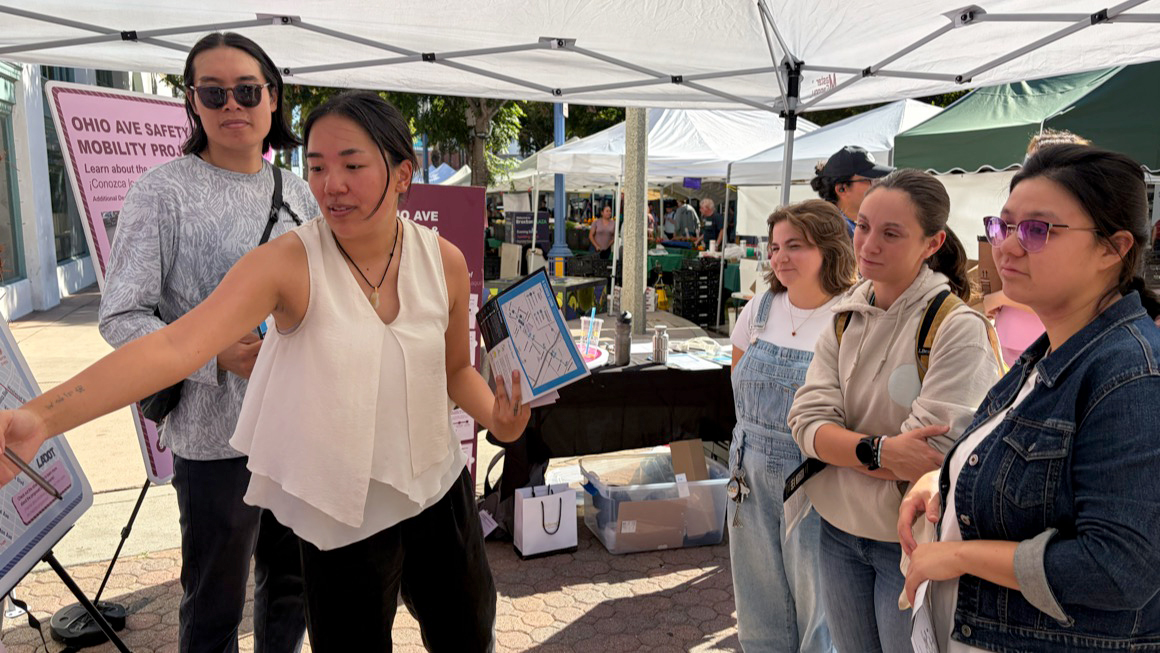
Putting this strategy into practice, the Los Angeles Department of Transportation (LADOT) is taking steps to strengthen how data and community insight inform its infrastructure decisions. By combining hyperlocal analysis with tailored engagement strategies, LADOT aims to ensure investments respond to the daily realities of Los Angeles residents.
What a hyperlocal data informed approach looks like
Our team worked with LADOT and local partners at Kounkuey Design Initiative (KDI) to conduct “social climate analyses” in four corridors across Los Angeles. These analyses were designed to inform LADOT’s engagement strategies by grounding outreach in both neighborhood-level data and residents’ lived experiences as pedestrians, cyclists, drivers, transit riders, workers, and business owners.
To ensure engagement reflected the needs of the full community, not just those most likely to attend traditional meetings, the analyses combined spatial data on income, language, disability, transportation access, housing insecurity, and severe traffic incidents with stories collected directly from residents. This mixed-methods approach surfaced clear patterns that shaped corridor-specific engagement recommendations.
Our on-the-ground partners at KDI and Fehr & Peers also walked the four corridors, documenting which intersections felt unsafe, where people gathered, and which businesses residents seemed to trust. These insights helped shape a block-by-block understanding of each corridor’s community, revealing sharply different engagement needs—even within the same city.
Across all corridors, we recommended best practices to support inclusive participation in any context. These included fully accessible engagement for people with disabilities; a mix of in-person and virtual formats, including small-group discussions; and clear communication about decisions, next steps, and how community input shaped outcomes.
Informing engagement in the Pico Boulevard and Ohio Avenue areas
The social climate analyses showed just how different neighborhoods across LA can be when approached through a hyperlocal lens. Two of the corridors we studied—the Pico Boulevard and the Ohio Avenue areas—showed clear differences in the types of engagement needed to surface the community’s infrastructure needs.
The Pico Boulevard area is predominantly Hispanic and Asian, with a significant share of people who do not speak English very well. Spanish is the most widely spoken language at home among those who do not speak English very well, followed by Korean (predominantly in the northwestern neighborhoods) and Chinese.
Based on these trends, our team advised local partners to provide outreach materials and host meetings in English and Spanish throughout the area and in Korean in specific neighborhoods. We also advised them to hold events in spaces where immigrant populations already gather and to protect the confidentiality of participants, as immigrants may be hesitant to engage because of safety concerns.
Other data points that directly informed engagement in the Pico Boulevard area include the following:
- More than 30 percent of households don’t have internet access, so we recommended outreach coordinators use multiple communication methods, including printed materials, phone outreach, in-person events, and mobile-friendly platforms.
- Approximately 12,000 households include children under 18, with nearly half led by single parents, so we recommended outreach coordinators offer onsite child care, organize family-centered events with activities for parents and children, and design outreach efforts that accommodate the schedules and needs of single-parent households.
Roughly seven miles across the city, residents of the Ohio Avenue area don’t uniformly resemble those of Pico Boulevard. Instead, most are white and Asian, and the area is home to a Veterans Affairs hospital that serves more than 84,000 veterans each year. It is also right next to the University of California, Los Angeles (UCLA), giving it a large college-age population. A significant share of Ohio Avenue residents speak English “very well” or better, but 11 percent speak English less than very well. Most of these residents who speak English less than very well speak other Indo-European languages, including Persian and Armenian.
Our analysis also showed that most Ohio Avenue residents (74 percent) are renters. However, renter households are mostly concentrated in the central tracts, while households in the outlying tracts are predominantly owner-occupied. Given previous evidence that owners are often overrepresented in community planning processes, we advised local partners to ensure homeowner voices didn’t outweigh those of renters, who represent the majority of residents.
Renters Are Concentrated in the North and Center of the Ohio Avenue Area
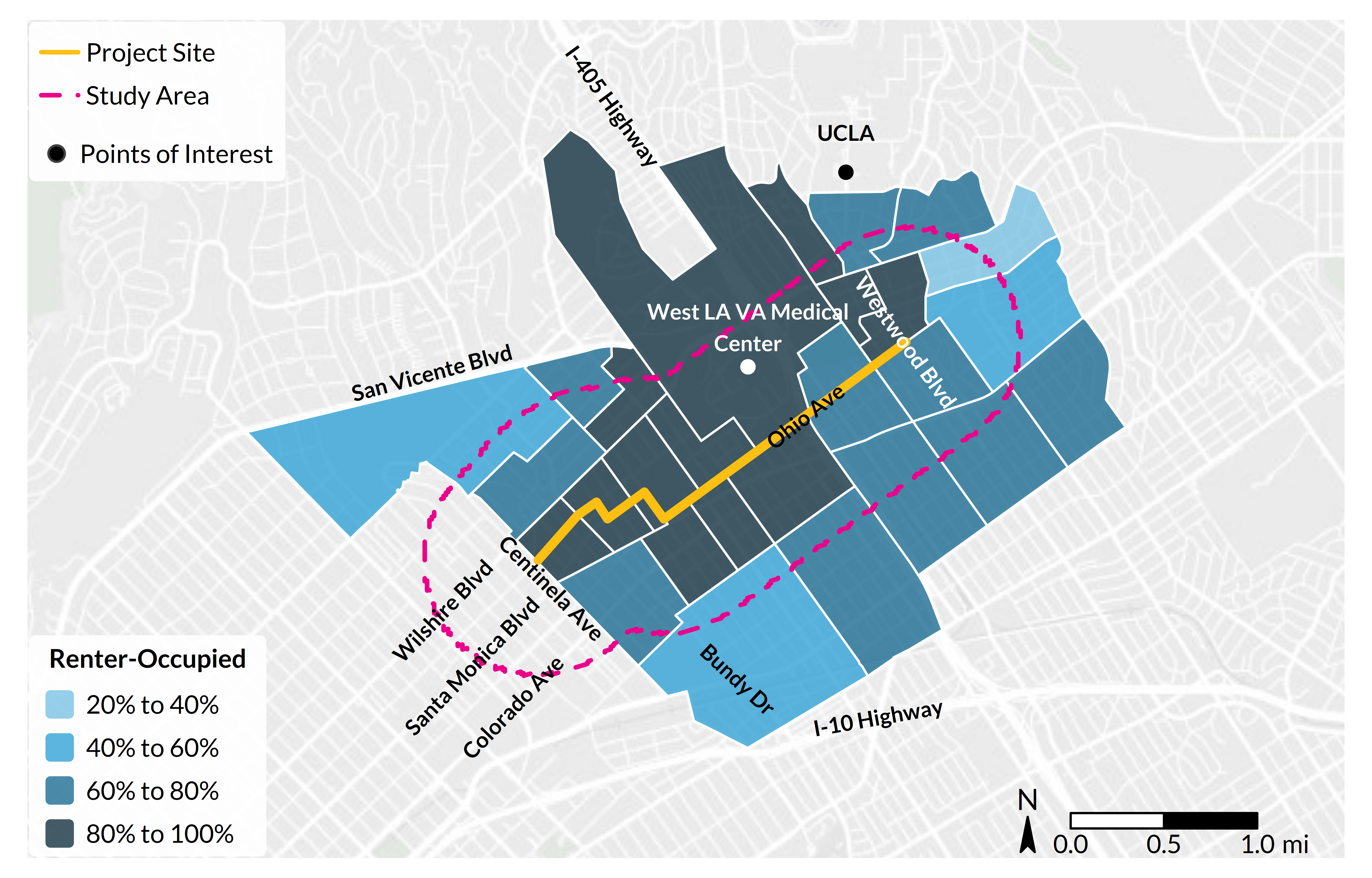
Source: Authors’ analysis of 2019–23 American Community Survey data, table B25003.
Based on these and other findings, we recommended that outreach coordinators:
- conduct engagement at large multifamily rental complexes to reach a broad base of renters;
- include materials targeting bikers and pedestrians, given the large share of active commuters in the area;
- provide outreach materials and host meetings in English, Spanish, and Farsi in targeted areas; and
- engage with veterans by putting marketing materials within the accessible shuttles, holding events in partnership with the West LA VA Medical Center, and conducting interviews and focus groups with veterans.
Finally, we advised the team to engage students at UCLA but to continue to ensure long-term residents had a proportionate voice in shaping discussions about the corridor.
Implications for other cities interested in hyperlocal engagement
This hyperlocal approach wasn’t about improving outreach for its own sake. By broadening who participates and what information is surfaced, the community engagement process can better shape the substance of planning decisions—what problems are prioritized, which trade-offs are considered acceptable, and how safety and mobility goals are defined.
In Los Angeles, this collaborative, hyperlocal approach encouraged engagement that included renters and people with low incomes, surfacing stronger preferences for protected bike lanes over parking spots—insights that may not have emerged through traditional engagement alone. Further, this initial analysis accounted for barriers to participating in the community engagement process, ultimately helping design street improvements that prioritize interventions where residents experience the greatest risk, not just where the loudest voices are heard.
LADOT now has a data-driven foundation for engagement and corridor designs, helping ensure mobility investments respond to real conditions on the ground. For other cities, the lesson is clear: Equitable outcomes require equitable inputs—and hyperlocal data can help make that possible.
Let’s help communities build more secure, hopeful futures.
Today’s complex challenges demand smarter solutions. Urban brings decades of expertise to understanding the forces shaping people’s lives and the systems that support them. With rigorous analysis and hands-on guidance, we help leaders across the country design, test, and scale solutions that build pathways for greater opportunity.
Your support makes this possible.