Climate-driven hazards such as floods and wildfires are growing more frequent and more severe, affecting communities across the United States. Zoning is one tool available to local governments to reduce the number of people and assets located in areas that are prone to hazards. However, communities lack data-driven understandings of where their zoning allows development in hazardous areas and what changes would encourage housing development that is resilient to our current and future climate.
Why This Matters
We present a prototype quantitative methodology—the Climate-Resilient Development Index (CRDI)—to describe how residential zoning relates to hazard exposure. This methodology enables communities to quantify how much of their housing stock is located in hazard-prone areas relative to the amount of housing that could be developed, per the zoning code, in less exposed areas.
The outputs of the CRDI answer critical questions about how a community’s zoning code allows (or does not allow) for ample housing in areas that are less exposed to climate hazards. It also provides insights into how zoning relates to climate risk equity (the shares of socially vulnerable households living in areas exposed to climate hazards) and resilient growth equity (the mix of different housing types, such as single-family or multifamily) allowed in less hazardous and more hazardous areas.
These data will provide planners, policymakers, and other key stakeholders with needed inputs to review their zoning codes with climate resilience in mind.
What We Found
We piloted the prototype CRDI in Mobile County, Alabama, an area with significant risk of sea level rise and flooding. The focus of this pilot effort was to explore the functionality of the CRDI and understand opportunities to enhance and scale this tool to other areas.
We found the following:
- The CRDI can highlight both where more resilient zoned capacity for housing is needed and where existing zoned capacity allows new development in hazard-prone areas.
- Future iterations of the CRDI should integrate additional hazards; this pilot focused only on flooding, but communities need a multihazard perspective.
- Inclusion of community infrastructure, such as transit, water, and sewer systems, can help describe which areas are both less climate-exposed and may be appropriate for additional zoned housing capacity.
How We Did It
We combined sociodemographic, parcel, zoning, flood hazard, and building data to estimate existing housing development and zoned capacity for additional housing development in areas that are exposed and less exposed to flood hazards. In figure 1, we present a visual overview of the CRDI analytic workflow.
Figure 1
Visual Overview of Data Analysis Workflow
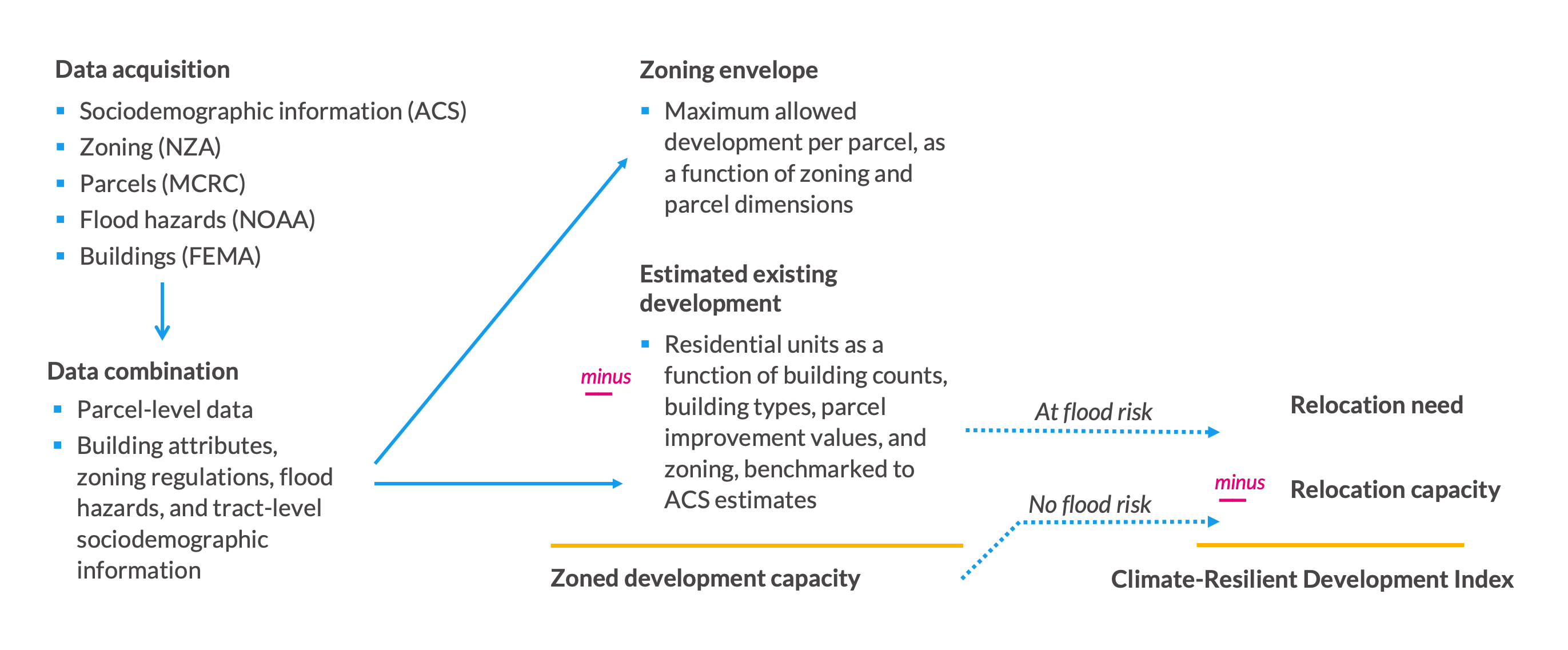
Source: Authors’ conceptual diagram.